The jagged shores of lake Mývatn, modeled by small peninsulas and little bays and coves, are the frames of a sparkling sketch of water and, together with it, set up one of the most iconic landscape of the Diamond Circle, of North of Iceland and of all the whole island. The main town of the area, Reykjahlíð, is located in the northeastern corner, on the Ring Road while unmissable places are simply everywhere.
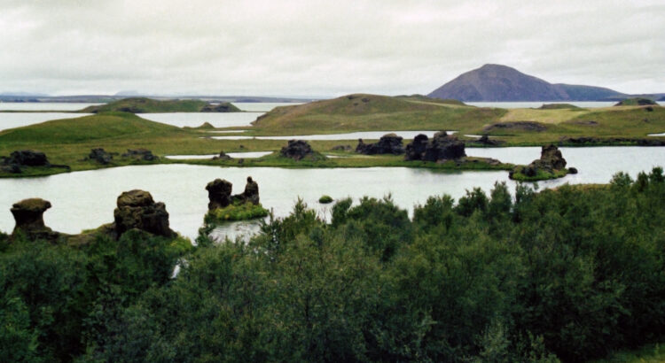
The northern part is where the lava field of Eldhraun stretches out. The eastern side is the most famous by far. A series of great attractions are here, including the promontory of Höfði in the southeastern corner of the lake. This is a tiny and pretty plot of land, a sort of peninsula, where bird lovers will find a true heaven. And in its southern part, at Kálfaströnd, the lake shows all its beauty off and suggesting klastar, lava pillars, arise over the water giving the landscape an even more surrealist look.
The southern shore of Mývatn is where the astonishing pseudo-craters, scattered all around the lake, are most easily accessible. At Skútustaðagígar the short circular trail is a unique chance to take a stroll and have a close look at these grassy bowls which were not vents from which lava erupted. They were created by explosions caused by steam and gas when, about 2.300 years ago, lava flowed above ground and hit the surface of the wetland. The pond at the center of the semicircular Skútustaðagígar, Stakhólstjörn, houses several colonies of waterbirds during the nesting season.
The western side of the lake is where Laxá river has its source (while the mouth is in Skjálfandi Flói, the bay where Húsavík lays). Extraordinary bird-watching opportunities follow one another along all the shore. The swamplands and the marshlands of this area are the places where thousands of birds come for nesting. And some of the species do that nowhere else in Iceland, such as the Common scoter, the Gadwall and the Barrow’s Goldeneye. The great Sigurgeir’s Bird Museum is the perfect place to integrate your bird-watching experience. Moreover this is the side where you can easily climb the 529mt of Vindbelgjarfjall to conquer the highest point in the proximity of the lake and the most stunning panorama.
How to get to Lake Mývatn?
If you’re coming from Húsavík drive 9km South on road n.85 and turn left at the junction with road n.87. 46km later you’ll get to Reykjahlíð.
If you’re coming from Akureyri simply follow road n.1 for 101km direction East in order to reach Reykjahlíð. And make sure you stop at Goðafoss on the way.
If you’re coming from the East (from Dettifoss, Krafla of Egilsstaðir) reach road n.1 and drive until the geothermal fields of Hverir. From here Reykjahlíð is 6km away, behind Námaskarð pass.
If you’re crossing the island from the South through Sprengisandur you need to reach road n.1. At the junction turn left and drive 49km direction East towards Reykjahlíð.
In order to reach all the other highlights in the area of the Mývatn there is a circular road circumnavigating the lake and reaching all the destinations. It actually is a combination of two roads. Road n.1, anticlockwise from the northeastern corner to the southwestern corner, and road n.848, clockwise from the northeastern corner to the southwestern corner.